DonateSupporterVisit Heritage
  • Tūrangawaewae
    Places
  • Tira Māori
    Māori Heritage
  • Poutairangahia
    Archaeology
  • Rauemi
    Resources
  • Mō Tātou
    About Us
  • New Zealand Heritage List
  • Nominate and submit
  • Explore the List
  • National Historic Landmarks
  • Plaques
  • Rainbow List Project
  • Lost heritage
  • Visit Heritage
  • Our properties
  • Turnbull House Project
  • Collections
  • Shop
  • Tohu Whenua
  • Tira Māori
  • Conserving Māori heritage
  • Marae built heritage
  • Māori heritage on the List
  • Hinemihi—Te Hokinga Mai
  • What is archaeology?
  • Is there a site on my property?
  • What are my legal requirements?
  • Affecting an archaeological site
  • Declaring an archaeological site
  • Archaeology FAQs
  • Archaeology Digital Library
  • Archaeology guidelines and templates
  • Resources
  • Funding
  • Publications
  • Sustainable management guides
  • Disaster recovery
  • Podcasts & digital resources
  • Education Hub
  • Conservation plans
  • About
  • Board
  • Māori Heritage Council
  • Senior Staff
  • Offices
  • Contact us
  • Careers
  • Covenants
  • Fast-track
  • Corporate documents
  • Currently consulting on
  • Our submissions
  • News
Quick links
Rārangi Kōrero | The List
Explore the List
National Historic Landmarks
Ngā Manawhenua o Aotearoa me ōna Kōrero Tūturu
Quick links
Tapuwae
A Vision for Places of Māori Heritage
Funding for Māori Heritage
Resources
Quick links
Archaeological Authority Portal
Applying for an archaeological authority
Archaeology FAQs
Browse the most frequently asked questions about archaeological authorities and the archaeological process.
Quick links
Quick links
Contact us
Offices
DonateSupporterVisit Heritage
  • Tūrangawaewae
    Places
  • Tira Māori
    Māori Heritage
  • Poutairangahia
    Archaeology
  • Rauemi
    Resources
  • Mō Tātou
    About Us
  • New Zealand Heritage List
  • Nominate and submit
  • Explore the List
  • National Historic Landmarks
  • Plaques
  • Rainbow List Project
  • Lost heritage
  • Visit Heritage
  • Our properties
  • Turnbull House Project
  • Collections
  • Shop
  • Tohu Whenua
  • Tira Māori
  • Conserving Māori heritage
  • Marae built heritage
  • Māori heritage on the List
  • Hinemihi—Te Hokinga Mai
  • What is archaeology?
  • Is there a site on my property?
  • What are my legal requirements?
  • Affecting an archaeological site
  • Declaring an archaeological site
  • Archaeology FAQs
  • Archaeology Digital Library
  • Archaeology guidelines and templates
  • Resources
  • Funding
  • Publications
  • Sustainable management guides
  • Disaster recovery
  • Podcasts & digital resources
  • Education Hub
  • Conservation plans
  • About
  • Board
  • Māori Heritage Council
  • Senior Staff
  • Offices
  • Contact us
  • Careers
  • Covenants
  • Fast-track
  • Corporate documents
  • Currently consulting on
  • Our submissions
  • News
Quick links
Rārangi Kōrero | The List
Explore the List
National Historic Landmarks
Ngā Manawhenua o Aotearoa me ōna Kōrero Tūturu
Quick links
Tapuwae
A Vision for Places of Māori Heritage
Funding for Māori Heritage
Resources
Quick links
Archaeological Authority Portal
Applying for an archaeological authority
Archaeology FAQs
Browse the most frequently asked questions about archaeological authorities and the archaeological process.
Quick links
Quick links
Contact us
Offices
  • Places
  • Nominate and submit
  • National Historic Landmarks
  • Places
  • Nominate and submit
  • National Historic Landmarks
  • Tira Māori
  • Conserving Māori heritage
  • Marae built heritage
  • Tira Māori
  • Conserving Māori heritage
  • Marae built heritage
  • Archaeological authorities
  • Archaeology Digital Library
  • Archaeological authorities
  • Archaeology Digital Library
  • All resources
  • Publications
  • Funding
  • All resources
  • Publications
  • Funding
  • FAQs
  • FAQs
Follow us on:
Places
  • Places
  • Nominate and submit
  • National Historic Landmarks
Tira Māori
  • Tira Māori
  • Conserving Māori heritage
  • Marae built heritage
Archaeology
  • Archaeological authorities
  • Archaeology Digital Library
Resources
  • All resources
  • Publications
  • Funding
FAQs
  • FAQs
Follow us on
HomePrivacyTerms and conditionsAbout this site
© Heritage New Zealand Pouhere Taonga 2026.
 
Northburn Tailings

Cromwell-Lindis Pass Highway, Quartz Reef Point, CENTRAL OTAGO

Public

Historic Place Category 2

List No. 5618

Quick links:
List GalleryLocationDetails
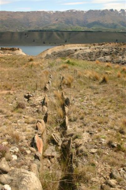
The spectacular tailings at Quartz Reef Point or Northburn provide an illustration of nineteenth century ground sluicing techniques used by gold miners in this confined area between the base of the Dunstan Range and the Clutha/Mata-au River.

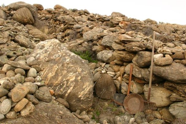
Geologist James Park wrote that there were three ’very rich’ alluvial leads at Quartz Reef Point. Ground sluicing involves directing the flow of ground water from a water race over the ground miners want to wash away. These tailings were part of an integrated series of features including two dams, an interconnecting head race, herringbone tailings, and the main supply race. The surviving features illustrate how ground sluicing worked. Water would have been released from holding dams and diverted through a head race over the work face, cleaning ‘gravel wash’ from the work face and creating ‘paddocks’ of gravel wash at the base of the bank. The head races are visible at the head of each herringbone finger. The wash had to be sorted to retrieve the gold while also maintaining the races and the sluice. Miners worked from the outer bank in and stacked stones at the bank edge to create a short wall and built a wall behind over which they heaped stones as the water washed the gold bearing gravels and sands down a narrow channel toward the central sluice. As the miners worked each new paddock toward the centre, a new short intermediate wall was created and the larger ‘herringbone’ wall was extended. The sluice, positioned in the central race, was the central focus of the mining operation. The sluice held gold trapping riffles, made from timber, stone, matting or tussock. There may have been a series of riffles further down the race to capture the finer gold missed by the first set.

The herringbone formations at Northburn are a product of the confined space – stones that miners could not throw from the working area had to be stacked neatly so prevent collapse back on the working area or into a sluice or race. Such a system required a lot of labour – it is likely that a number of groups working at the same time created the existing system of herringbone tailings. The pattern of the tailings also reflects the gold miner’s strength – often the distance between the herringbone walls was the distance a person could throw a stone. Hundreds of thousands of cubic metres of material was removed via tail races and discharged into the Clutha/Mata-au River.

Mining had largely ended the early years of the twentieth century, after which the tailings were incorporated into Northburn Station. They were declared as a historic reserve in 1977. In 2015, visitors can see the tailings as part of the Quartz Reef Point walk.
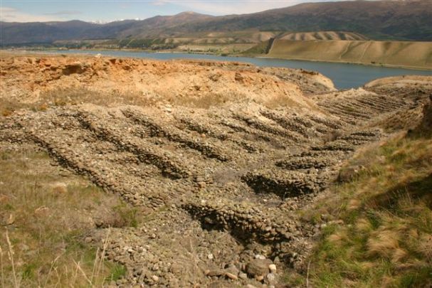
Northburn Tailings | Marion Sutton | 01/10/2006 | Department of Conservation

List Entry Information

Overview

Status
Listed

List Entry Status
Historic Place Category 2

Access
Able to Visit

List Number
5618

Date Entered
11th April 1985

Date of Effect
11th April 1985

City/District Council
Central Otago District

Region
Otago Region

Extent of List Entry

Extent includes the land described as Lot 1 DP 16004 (RT OT7B/455), Otago Land District, and the Northburn Tailings thereon.

Legal description

Lot 1 DP 16004 (RT OT7B/455), Otago Land District

Location Description

Off State Highway 8 between Cromwell and Crippletown. Access via Department of Conservation easement.

Detailed List Entry
Reference

Historical and Associated Iwi / Hapū / Whānau

Iwi

Ngāi Tahu

Public NZAA Number

G41/554

Completion Date

11th February 2015

Report Written By

Heather Bauchop

Report Written By

This place was identified as significant under previous legislation with different information requirements. It remains significant under the current legislation. There is opportunity under our legislation and policies to add to this information. Further information about this place may be available from the Otago/Southland Office of Heritage New Zealand Pouhere Taonga. Please note that entry on the New Zealand Heritage List/Rarangi Korero identifies only the heritage values of the property concerned, and should not be construed as advice on the state of the property, or as a comment of its soundness or safety, including in regard to earthquake risk, safety in the event of fire, or insanitary conditions. A fully referenced upgrade report is available on request from the Otago/Southland Office of Heritage New Zealand

Further Information

Current Usages

Uses: Civic Facilities

Specific Usage: Historic or recreation reserve

Former Usages

General Usage:: Mining

Specific Usage: Mine Tailings

General Usage:: Mining

Specific Usage: Mine Water Race/ Water Race cuttings/tunnels etc

Themes

Web Links

description: Department of Conservation walking track link.

url: http://www.doc.govt.nz/parks-and-recreation/tracks-and-walks/otago/central-otago/quartz-reef-point-walk/

Overview

Status

Listed

List Entry Status

Historic Place Category 2

Access

Able to Visit

List Number

5618

Date Entered

11th April 1985

Date of Effect

11th April 1985

City/District Council

Central Otago District

Region

Otago Region

Extent of List Entry

Extent includes the land described as Lot 1 DP 16004 (RT OT7B/455), Otago Land District, and the Northburn Tailings thereon.

Legal description

Lot 1 DP 16004 (RT OT7B/455), Otago Land District

Location Description

Off State Highway 8 between Cromwell and Crippletown. Access via Department of Conservation easement.

Status

Listed

List Entry Status

Historic Place Category 2

Access

Able to Visit

List Number

5618

Date Entered

11th April 1985

Date of Effect

11th April 1985

City/District Council

Central Otago District

Region

Otago Region

Extent of List Entry

Extent includes the land described as Lot 1 DP 16004 (RT OT7B/455), Otago Land District, and the Northburn Tailings thereon.

Legal description

Lot 1 DP 16004 (RT OT7B/455), Otago Land District

Location Description

Off State Highway 8 between Cromwell and Crippletown. Access via Department of Conservation easement.

Reference

Historical and Associated Iwi / Hapū / Whānau

Iwi: Ngāi Tahu

Public NZAA Number

G41/554

Completion Date

11th February 2015

Report Written By

Heather Bauchop

Other Information

This place was identified as significant under previous legislation with different information requirements. It remains significant under the current legislation. There is opportunity under our legislation and policies to add to this information. Further information about this place may be available from the Otago/Southland Office of Heritage New Zealand Pouhere Taonga. Please note that entry on the New Zealand Heritage List/Rarangi Korero identifies only the heritage values of the property concerned, and should not be construed as advice on the state of the property, or as a comment of its soundness or safety, including in regard to earthquake risk, safety in the event of fire, or insanitary conditions. A fully referenced upgrade report is available on request from the Otago/Southland Office of Heritage New Zealand

Historical and Associated Iwi / Hapū / Whānau

Iwi: Ngāi Tahu

Public NZAA Number

G41/554

Completion Date

11th February 2015

Report Written By

Heather Bauchop

Other Information

This place was identified as significant under previous legislation with different information requirements. It remains significant under the current legislation. There is opportunity under our legislation and policies to add to this information. Further information about this place may be available from the Otago/Southland Office of Heritage New Zealand Pouhere Taonga. Please note that entry on the New Zealand Heritage List/Rarangi Korero identifies only the heritage values of the property concerned, and should not be construed as advice on the state of the property, or as a comment of its soundness or safety, including in regard to earthquake risk, safety in the event of fire, or insanitary conditions. A fully referenced upgrade report is available on request from the Otago/Southland Office of Heritage New Zealand

Further Information

Current Usages

Uses: Civic Facilities

Specific Usage: Historic or recreation reserve

Former Usages

General Usage: Mining

Specific Usage: Mine Tailings

General Usage: Mining

Specific Usage: Mine Water Race/ Water Race cuttings/tunnels etc

Web Links

description: Department of Conservation walking track link.

url: http://www.doc.govt.nz/parks-and-recreation/tracks-and-walks/otago/central-otago/quartz-reef-point-walk/

Current Usages

Uses: Civic Facilities

Specific Usage: Historic or recreation reserve

Former Usages

General Usage: Mining

Specific Usage: Mine Tailings

General Usage: Mining

Specific Usage: Mine Water Race/ Water Race cuttings/tunnels etc

Web Links

description: Department of Conservation walking track link.

url: http://www.doc.govt.nz/parks-and-recreation/tracks-and-walks/otago/central-otago/quartz-reef-point-walk/

Location

Loading
Sign up to hear more

Get the latest heritage news, features and events delivered
straight to your inbox.

Subscribe